Sunday, March 2, 2014

The Amazon Rainforest, South America

Amazon Rainforest
The Amazon rainforest, also known in English as Amazonia or the Amazon Jungle, is a moist broadleaf forest that covers most of the Amazon Basin of South America.


The Amazon River Basin is home to the largest rainforest on Earth. The basin -- roughly the size of the forty-eight contiguous United States -- covers some 40% of the South American continent and includes parts of eight South American countries.


Reflecting environmental conditions as well as past human influence, the Amazon is made up of a mosaic of ecosystems and vegetation types including rainforests, seasonal forests, deciduous forests, flooded forests, and savannas. The basin is drained by the Amazon River, the world's largest river in terms of discharge, and the second longest river in the world after the Nile. The river is made up of over 1,100 tributaries, 17 of which are longer than 1000 miles, and two of which (the Negro and the Madeira) are larger, in terms of volume, than the Congo (formerly the Zaire) river. The river system is the lifeline of the forest and its history plays an important part in the development of its rainforests. 


Giant’s Causeway, Ireland


Giant's Causeway

Situated on the North Coast of Irelanf in County Antrim (about two miles north of Bushmills, 11 miles from Coleraine and 13 miles from Ballycastle), the Giant's Causeway is an area of approximately 40,100 interlocking basalt columns, the result of an ancient volcanic eruption.
Giant's Causeway is geological wonder located on the Northern shores of Ireland and is comprised of 40,000 adjoining pillars of basalt formed by a prehistoric volcanic outbreak. It was discovered in 1739 by an Irish water color artist named Susanna Drury while painting the spectacular landscape. It is home to bird species such as cormorant, redshank guillemot, fulmar, shag, petrel. and razorbill added with rare sea plants like frog orchid, sea fescue, vernal quill, trefoil, hare's foot, and sea spleenwort.

Proclaimed among the top wonders of the UK, it was finally recognized as a World Heritage Site in 1986. The extraordinary formation of rocks and the overpowering whiff of the sea is an immense attraction for tourist looking for nature-loving activities like seeing wildlife, hiking, and exploring natural phenomenon.


Saturday, March 1, 2014

Chocolate Hills

Chocolate Hills
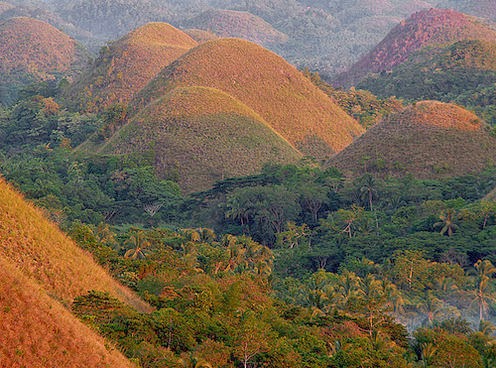
The Chocolate Hills is a geological formation in Bohol Province, Philippines. There are at least 1,260 hills but there may be as many as 1,776 hills spread over an area of more than 50 square kilometres.
The Chocolate Hills are probably Bohol's most famous tourist attraction. They look like giant mole hills, or as some say, women's breasts, and remind us of the hills in a small child's drawing. Most people who first see pictures of this landscape can hardly believe that these hills are not a man-made artifact. However, this idea is quickly abandoned, as the effort would surely surpass the construction of the pyramids in Egypt. 

The chocolate hills consist of are no less than 1268 hills (some claim this to be the exact number). They are very uniform in shape and mostly between 30 and 50 meters high. They are covered with grass, which, at the end of the dry season, turns chocolate brown. From this color, the hills derive their name. At other times, the hills are green, and the association may be a bit difficult to make.


Legend has it that the hills came into existence when two giants threw stones and sand at each other in a fight that lasted for days. When they were finally exhausted, they made friends and left the island, but left behind the mess they made. For the more romantically inclined is the tale of Arogo, a young and very strong giant who fell in love with an ordinary mortal girl called Aloya. After she died, the giant Arogo cried bitterly. His tears then turned into hills, as a lasting proof of his grief.

The Roman Colloseum,Italy

The Colloseum

The Colosseum or Coliseum, also known as the Flavian Amphitheatre is an elliptical amphitheatre in the centre of the city of Rome, Italy.

The Colosseum was covered with an enormous awning known as the velarium. This protected the spectators from the sun. It was attached to large poles on top of the Colosseum and anchored to the ground by large ropes. A team of some 1,000 men was used to install the awning.

Emperors used the Colosseum to entertain the public with free games. Those games were a symbol of prestige and power and they were a way for an emperor to increase his popularity.

Games were held for a whole day or even several days in a row. They usually started with comical acts and displays of exotic animals and ended with fights to the death between animals and gladiators or between gladiators. These fighters were usually slaves, prisoners of war or condemned criminals. Sometimes free Romans and even emperors took part in the action.

Machu Picchu, Peru

Machu Picchu
Machu Picchu is a 15th century Inca site located 2,430 meters above sea level. It is located in the Cusco Region, Urubamba Province, Machu Picchu District in Peru.
Machu Picchu located in the ,iddle of a tropical mountain forest, in an extraordinarily beautiful setting. It was probably the most amazing urban creation of the Inca Empire at its height; its giant walls, terraces and ramps seem as if they have been cut naturally in the continuous rock escarpments. The natural setting, on the eastern slopes of the Andes, encompasses the upper Amazon basin with its rich diversity of flora and fauna.

Archaeologists estimate that approximately 1200 people could have lived in the area, though many theorize it was most likely a retreat for Incan rulers. Due to it’s isolation from the rest of Peru, living in the area full time would require traveling great distances just to reach the nearest village.

Separated into three areas - agricultural, urban, and religious - the structures are arranged so that the function of the buildings matches the form of their surroundings. The agricultural terracing and aqueducts take advantage of the natural slopes; the lower areas contain buildings occupied by farmers and teachers, and the most important religious areas are located at the crest of the hill, overlooking the lush Urubamba Valley thousands of feet below.


Niagara Falls, Canada

Niagara Falls


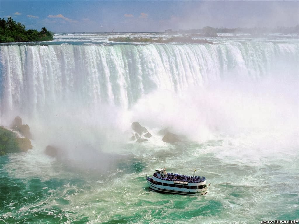
A North American natural wonder, Niagara Falls flows with scenic might through Niagara Falls State Park. And just beyond its waterfall vistas, Niagara is filled with splendid discoveries and fantastic attractions.

Pictures are great, but getting close enough to touch Niagara Falls inspires genuine awe. Millions of gallons of water rocket over Niagara Falls every minute – about 750,000 gallons each second! There’s no closer place to “feel Niagara’s flow” than from the decks, boats, vista points and trails of Niagara Falls State Park - America’s oldest state park. 

With sparkling scenery, thrilling attractions, family-friendly and interactive exhibits, miles of hiking trails and  delectable dining options, Niagara Falls State Park gets you closer to the Falls than anywhere else. The park features classic adventures and vacation amenities to make the most of your trip, and no passport is needed to experience an unforgettable and breathtaking Niagara Falls vacation.


The Great Wall of China, China

The Great Wall of China

The Great Wall of China is not a continuous wall but is a collection of short walls that often follow the crest of hills on the southern edge of the Mongolian plain. The Great Wall of China, known as "long Wall of 10,000 Li" in China, extends about 8,850 kilometers (5,500 miles).

A first set of walls, designed to keep Mongol nomads out of China, were built of earth and stones in wood frames during the Qin Dynasty (221-206 BCE).


Some additions and modifications were made to these simple walls over the next millennium but the major construction of the "modern" walls began in the Ming Dynasty (1388-1644 CE).

The Ming fortifications were established in new areas from the Qin walls. They were up to 25 feet (7.6 meters) high, 15 to 30 feet (4.6 to 9.1 meters) wide at the base, and from 9 to 12 feet (2.7 to 3.7 meters) wide at the top (wide enough for marching troops or wagons). At regular intervals, guard stations and watch towers were established.

Since the Great Wall was discontinuous, Mongol invaders had no trouble breaching the wall by going around it, so the wall proved unsuccessful and was eventually abandoned. Additionally, a policy of mollification during the subsequent Ch'ing Dynasty that sought to pacify the Mongol leaders through religious conversion also helped to limit the need for the wall.


Through Western contact with China from the 17th through 20th centuries, the legend of the Great Wall of China grew along with tourism to the wall. Restoration and rebuilding took place in the 20th century and in 1987 the Great Wall of China was made a World Heritage Site. Today, a portion of the Great Wall of China about 50 miles (80 km) from Beijing receives thousands of tourists each day.